
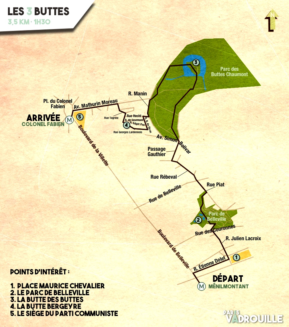
- Download/View Walk Map
- 3,5 kms / About 1:30 hrs
- Start : Metro station Ménilmontant (Line 2)
- Arrivée : Metro station Colonel Fabien (Line 2)
- Any season (more flowery during warmer seasons, clearer views in winter)

Notre-Dame de La Croix church in rue Dolet.
Maurice Chevalier square and Notre-Dame de la Croix church
Just oustide the Métro, walk up the Boulevard de Belleville for a few metres then turn right into rue Étienne Dolet. In the distance, while not that noticeable from rue de Ménilmontant, you will not miss Notre-Dame de la Croix church, mightily towering over Maurice Chevalier square since its completion (late 19th century). You will catch a better glace at the square from the top of the stairs leading to the church. Turning your back to the church, take the rue Julien Lacroix on the right. Further down this street you will come across the quiet rue de l’Élysée Ménilmontant, named after a popular ballroom in the 1860s. Walk on, following rue Lacroix until rue des Couronnes and cross the street to enter Belleville park.

One of the entrances to Belleville park, from rue des Couronnes.
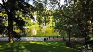
Belleville Hill
The labyrinthine structure of this park, with its network of paths and terraced lawns, makes it easy to miss out on its features (and stray cats). The best way to have an idea of the area is to go up, which is only convenient since Belleville ranks as the 2nd highest point in Paris (128m), just behind Montmartre (130m). There are many ways to reach the gazebo sitting at the top of the park, and we encourage you to explore the area the way you want (and if you feel lost, just get higher). Whatever the paths you take on your way up, you will be rewarded with a panoramic view over Paris. Turn around and walk down rue Piat, on the left. Cross the rue de Belleville and follow on rue de Rébeval. Take a left into the quaint and quiet passage Gauthier, climb up the steps at the other end, cross the street and finally enter the Buttes Chaumont opposite.
Les Buttes Chaumont.
Chaumont Hills
The Buttes Chaumont, with its highest point peaking at 103m, is one of the most popular Parisian landmarks. Thousands of visitors come daily to seek shade or calm, away from the city. But little do they know that this place used to serve different purposes during its existence. It was first a gypsum quarry in the 1860s, then a landfill, and a water treatment plant — not the most bucolic place in the area — until its total makeover in 1867 when it opened as a recreational park. From the entrance, follow the main path (avenue Jacques de Liniers) until you get a glimpse of the central steep peak, one of the most obvious reminders of the park’s origins as a quarry. Follow the path winding down to it and cross the Pont des Suicidés, a massive stone bridge whose name — roughly translating as “Suicide Bridge” — does not really need explaining as regards its origin. When you reach the top of the peak, facing west, you will find the Temple of the Sybil, overlooking the whole park and beyond. Turn back and walk down the peak and cross the wobbly-but-perfectly-safe suspension footbridge. On the other side, turn left into avenue Alphand, walk past the Pavillon du Parc, and up to avenue des Marnes and exit the parc. Walk up rue Manin on the left for a few more steps and climb the stairs opposite the street, between numbers 17 and 21.
Bergeyre Hill

La Butte Bergeyre, rue Georges Lardennois.
You have reached the butte Bergeyre, a small residential block peaking at 100m, mostly flanked with low-rise buildings, front yards and a small vineyard. The name of this place comes from the stadium that used to sit here in the 1920s, named after a Vaugirard Rugby Club player, fallen during WWI. On top of the stairs, turn left onto rue Barrelet de Ricou to have a look around. The place does not spread out much, so you can also wander through the narrow E.-A. Poe and de Gourmont streets. Go to the Gourmont/Lardenois angle in front of the Butte Bergeyre garden, where you will find vineyards and beehives, as well as a gorgeous view on the neighbouring Montmartre hill. If the garden is open, you can walk through it down to rue de Chaufourniers and reach avenue Mathurin Moreau after avenue Simon Bolivar. If the garden is closed, you can keep exploring and walk down the steps of the small “rue” Michel Tagrine (more like a flight of stairs, really) further down on the left and then straight ahead towards avenue Moreau.

The French Communist party headquarters.
The PCF headquarters at the PCF
This brilliant acronym-based pun doesn’t really work in English : PCF refers to both Parti Communiste Français (French Communist Party) and Place du Colonel Fabien (Colonel Fabien Square). Anyway — they can both be reached at the bottom of avenue Mathurin Moreau. The PCF headquarters and the cupola lying in front of it were designed in 1971 by Brazilian architect Niemeyer (who designed most of Brasìlia’s modern buildings) and the glass facade was designed by Paris-born architect Jean Prouvé. On the square you will find the Metro station Colonel Fabien, the ending point of the walk.
